Just days after a large swath of southern Alberta was hit with its first big snowfall of the winter, there’s another storm system bearing down on the province.

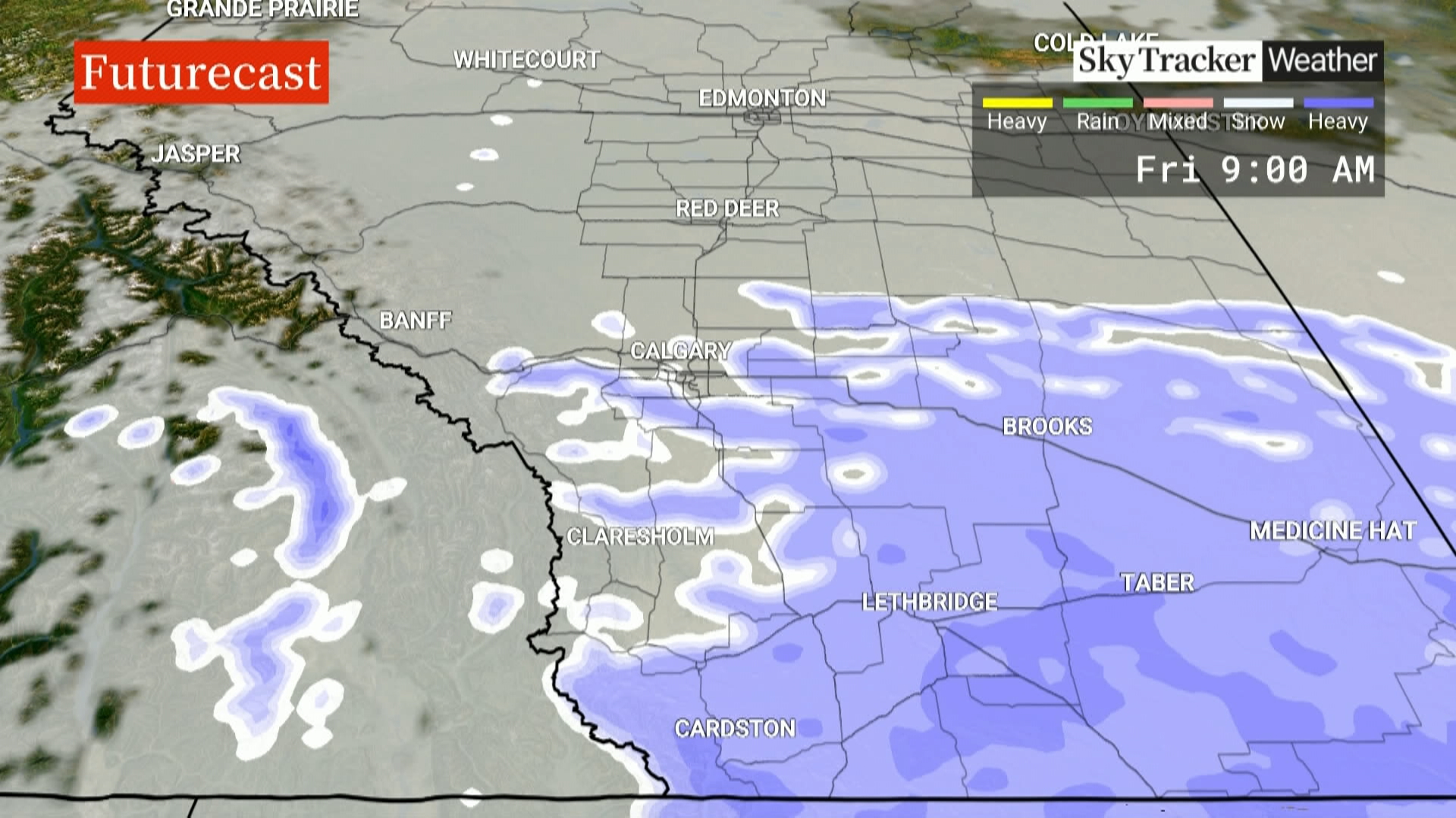
Environment Canada is forecasting the snow to start falling Thursday afternoon in the form of flurries for Edmonton and Calgary, while more southerly communities such as Lethbridge and Medicine Hat are expected to see heavier snowfall.
“As we progress through Thursday afternoon and into the evening hours, snow moves up from the southwest and does reach the Calgary area right around the late supper hour and into the overnight, and eventually will cover most of the region,” said Global News weather specialist Phil Darlington.
“It does taper off Friday morning, so the commute for Thursday evening (will be) not so bad, but Friday morning you are going to want to take your time,” added Darlington.
Story continues below advertisementSome areas of the southern foothills and extreme southerly parts of the province could get up to 25 cm by the time the snow starts to taper off Friday night.
 View image in full screen
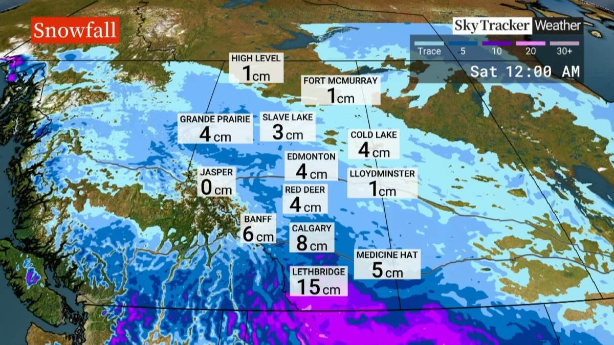
The heaviest snow is expected to fall over the extreme southerly parts of Alberta where between 15 and 25 centimetres of snow is forecast for Lethbridge and into the foothills.
Global News
View image in full screen
The heaviest snow is expected to fall over the extreme southerly parts of Alberta where between 15 and 25 centimetres of snow is forecast for Lethbridge and into the foothills.
Global News
The temperatures are also expected to plunge, with the daytime high forecast to be around -10 C on Friday and Saturday, well below the normal daytime high of around zero at this time of year.

Get daily National news
Get the day's top news, political, economic, and current affairs headlines, delivered to your inbox once a day. Sign up for daily National newsletter Sign Up By providing your email address, you have read and agree to Global News' Terms and Conditions and Privacy Policy.Overnight temperatures in Lethbridge and Medicine Hat could also dip to near -20 C, about 10 degrees below normal.
The sudden arrival of winter is being blamed on the ‘polar vortex‘, a large area of low pressure and cold air surrounding the north pole that is sending abnormally cold and stormy weather into the more populated areas of North America.
While the weather phenomenon can last anywhere from a few days to a few weeks, Global New meteorologist Anthony Farnell says “computer models from past years with similar November weather patterns are all pointing towards a colder-than-normal December in Canada.”
Story continues below advertisement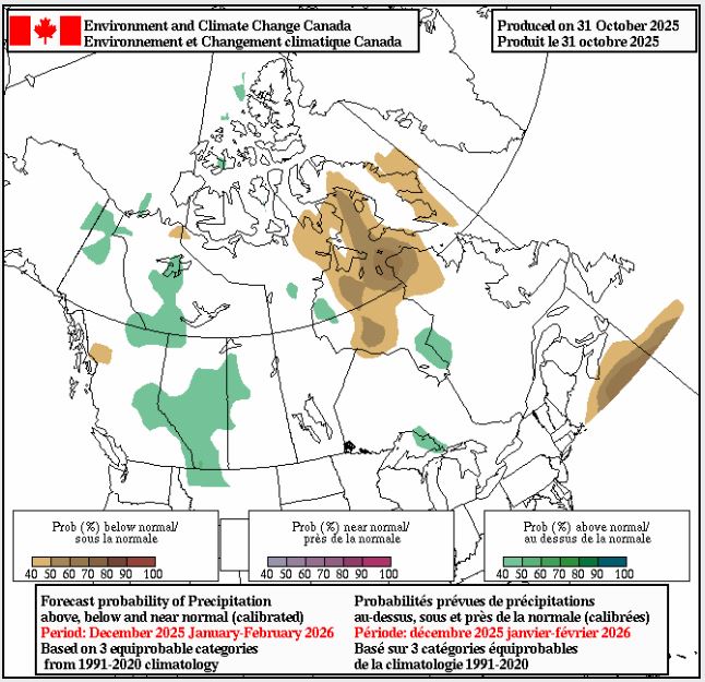 Envrionment Canada’s latest seasonal forecast predicts higher-than-normal snowfall across much of Alberta this winter.
Source: Environment Canada
Envrionment Canada’s latest seasonal forecast predicts higher-than-normal snowfall across much of Alberta this winter.
Source: Environment Canada
The seasonal forecast from Environment Canada also predicts higher-than-normal snowfall amounts over much of Alberta for the months of December, January and February.
 1:54
Polar vortex set to bring early winter blast to much of Canada next week
Related News
1:54
Polar vortex set to bring early winter blast to much of Canada next week
Related News
- Polar vortex set to bring ‘harsh early start to winter’ across Canada
- Heavy snow causes chaos on the roads in southern Alberta
- Heavy snow forecast prompts warning of possible avalanches in Rocky Mountains
- A snowy showdown: Canadian soccer players shovel snow, plows clear field

